Where ???
|
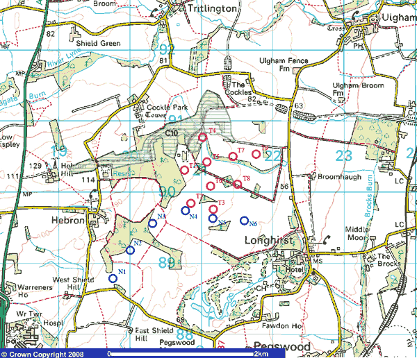
Currently 2 companies have submitted proposals for a wind farm in Longhirst:I have taken the information of both companies and have included them in a map:
The red circles represent turbines of the RES-Ltd proposal, the blue circles of Novera Energy. As you can see, the turbines T2 & T3 from RES-Ltd are are pretty much at the same location as N4 & N5 of Novera Energy. I assume T2 & T3 will not be buildt, which would fit to the statement, that current development work of RES-Ltd seem to be pointing towards a 7 turbine layout. Further I have included an area marked as C10, which is a 'site of local conservation interest' in the Castle Morpeth Local Plan (more about this here). I have written a small java applet, to calculate the distance of proposed turbines to your house. Please note, that the only distance we know for sure is the one of the testmast, but I think we can see the distance of the closest mast as an indication, how close they might come to our properties.The applet is based on the 9 turbine layout of RES-Ltd and the 6 turbines of Novera Energy. Once I have turbine positions of an application for a planning permission, I will update this applet.Enter the position of your house as Ordnance survey coordinates. You can get your OS coordinates of course from your OS map, but the easiest way is by using Streetmap's gridconverter (click here). (OS X would be the Eastings and OS Y the Northings...). The coordinates provided here are for Broomhaugh. The testmast which you can see in the field of Butterwell farm is 80m high. Here some other coordinates:
|